Buying, appraising and building real estate requires an intense examination of building and planning laws. In this respect, the following documents, statutes and ordinances are paramount:
- Local building codes and zoning ordinances under the zoning plan.
- Cantonal land use planning laws and regulatory statutes.
- Court rulings and decrees.
In the following discussion, we take a closer look at these, and briefly explain the most important terms. Both the definitions and the figures shown here originate from one of the relevant legal documents, namely the “PBG” (German abbreviation for the Canton of Zurich’s “Land Use Planning and Public Building Act”; we‘ll use this abbreviation hereafter). For the sake of clarity and simplicity, we will dispense with naming the exact citation (i.e., the specific article and line in the PBG).
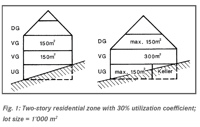
1. Utilization coefficient
The utilization coefficient takes into account any and all spaces that are used for residential, work or any other form of continuous habitation. Only the areas on a full floor of a building are factored into utilization; however, utilization will also include access areas (foyers, hallways) and sanitation rooms and the internal partition walls. The area on the top floors (i.e., attic, loft or rooftop level) and in the basements consume utilization if, per floor, they exceed the area that would result by dividing up the entire allowable utilization equally across the allowed number of floors. When calculating the utilization coefficient, top floors and basements that replace a full floor are considered full floors; this also applies to basements in which the majority of the space is situated above ground, i.e., above the natural terrain.
The following municipalities around Lake Zurich have a utilization coefficient in their building codes: Erlenbach, Hombrechtikon / Feldbach, Thalwil, Oberrieden, Wädenswil, Richterswil.
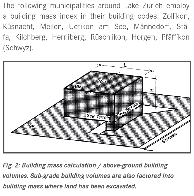
2. Building mass
The “building mass” number indicates how many cubic meters of improved (built) volume are permitted per square meter of land area. To calculate the building mass index, only the above-ground improved space (visible cubature) is measured, using its exterior dimensions. There is a simple formula for computing building mass:

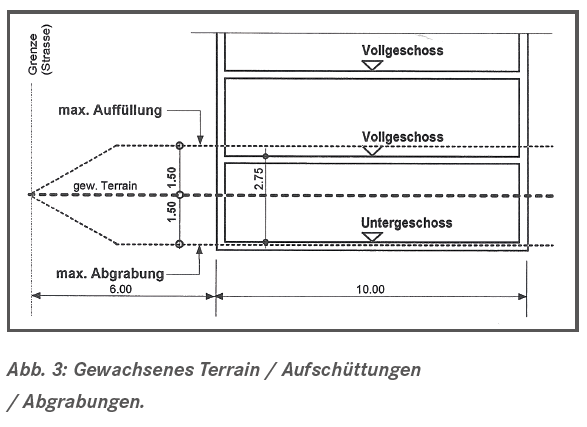
3. Natural terrain
What course of terrain is relevant to measuring the maximum building height today? When is terrain considered “backfill” – an added soil layer – and when is it considered “natural”? Over the last few years, the issue of “natural terrain” has triggered a number of disputes, especially when calculating permissible building mass and building height. For the Canton of Zurich, a court ruling has clarified the issue:
- One must be able to trace the history of the terrain to the submission date at that time of the master plan.
- In the case of new buildings, today‘s terrain may be parked if no change has been made in the last 30 years.
This regulation is not a law; rather, it is a practice derived from a court decision. Hence, it could be reinterpreted again at any time by the courts.
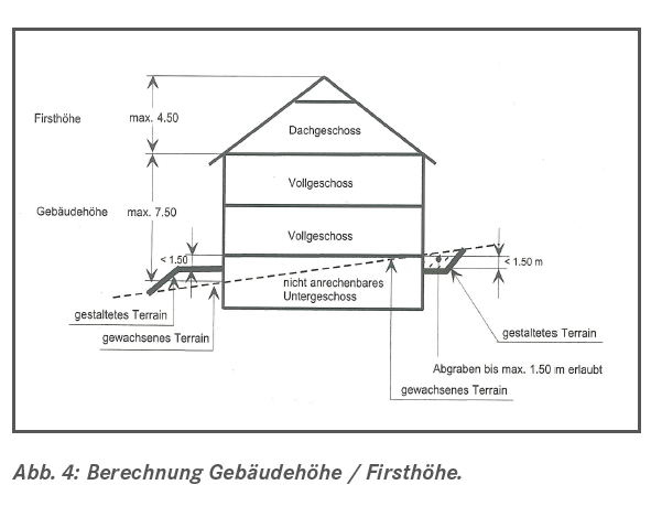
4. Building height
The permissible building height is determined by the allowed number of full floors, or by the building code and zoning ordinance. Unless the building code and zoning ordinance stipulate otherwise, according to the PBG, one can expect the building height to be based on the allowed number of full floors that have a gross floor height of 3.3 meters (or 4 meters in the downtown area and industrial zones, and additionally 1.5 meters for the ground floor elevation). The permissible building height is measured by each intersection line between façade and roof areas above the building‘s underlying natural terrain. The ridge height is the permissible height for the top floor, which is normally permitted in addition to the building height.
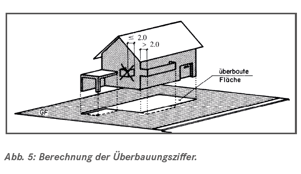
5. Structural index
The allowable area for the structural index is based on the vertical projection of the largest above-ground exterior building outline on the ground. The index does not include: above-ground, enclosed elements that project from the building by up to 1.5 meters; above-ground, projecting elements (such as balconies) up to a depth of 2 meters; bay windows; porches or pergolas – provided, however, that their dimensions do not exceed one-third of the subject façade. Beside the structural index, local building authorities may also stipulate an open-space index. This restriction is typically applied instead of a maximum structural index.
6. Building lines
Building lines secure the land for structures and systems in the public interest, such as streets, walkways, open spaces, utilities, etc. They are an essential land use planning tool for transportation and site access planning. To that end, in principle, the land situated between building lines is subject to a construction ban. As a rule, one can use the land within the building lines for above-ground building projections of up to a maximum of 1.5 meters, e.g. for retaining walls, container space, vehicle parking, etc. As soon as one applies for a building permit within the building lines, the state will record a property ownership restriction in the land registry, subject to public law. In other words, the state might grant a building permit (e.g., for a retaining wall); however, it will also be explicitly stated in the permit and in the land registry that if the state must use the land within the building lines (e.g., to build a sidewalk), then the existing structures must be dismantled, without compensation, and at the builder‘s expense.
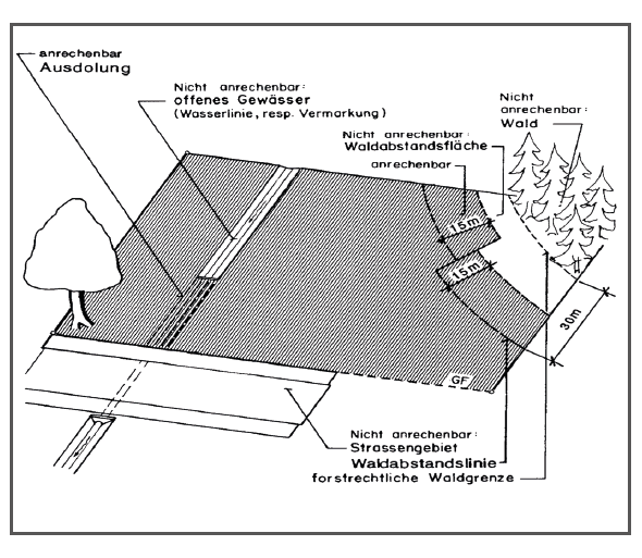
7. Forest and water buffer lines
Development zones in proximity to forests or bodies of water are usually affected by forest or water buffer lines. Normally, forest buffer lines are set at distances of 30 meters from the boundary with the forest. For small forest parcels or where there are particular local conditions, they may be drawn either closer or farther from the forest boundary. When calculating the land area relevant to utilization or building mass, when there is also a forest buffer, one must also note that any areas within a 15 meter distance from the forest buffer line cannot be factored in. For example, if you have a 40 meter strip of land that borders a forest, and extends 50 meters away (i.e., 40 m x 50 m lot, or a 2,000 m2), the first 15 meters are not considered relevant land area for your development calculations. In other words: only a 25 m x 50 m space can be used as the land area to factor into utilization or building mass computations (1,250 m2).
Useful links
- PBG (Kanton Zürich)
- Geografisches Informationssystem des Kantons Zürich
- Infoblatt Bauen im Waldabstandsbereich
Author: Claude Ginesta

Claude A. Ginesta is a federally licensed real estate fiduciary (registered with the SVIT, the Swiss Federation of Real Estate Fiduciaries) and owner and CEO of Ginesta Real Estate AG. The company was founded in 1944 and specializes in the sale of properties in the Zurich and Grisons markets. With offices in Küsnacht, Horgen and Chur, the company operates as real estate broker throughout Switzerland for properties located across the country.
Publisher of the “Illusions” series: Ginesta Real Estate AG, www.ginesta.ch


